
Sobral Pichorro topographic map
Interactive map
Click on the map to display elevation.
About this map
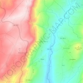
Name: Sobral Pichorro topographic map, elevation, terrain.
Average elevation: 564 m
Minimum elevation: 386 m
Maximum elevation: 765 m
Other topographic maps
Click on a map to view its topography, its elevation and its terrain.
Mata
Portugal > Guarda > Sobral Pichorro e Fuinhas > Sobral Pichorro
Mata, Sobral Pichorro, Sobral Pichorro e Fuinhas, Fornos de Algodres, Guarda, 6370-382, Portugal
Average elevation: 544 m
Fuinhas
Portugal > Guarda > Sobral Pichorro e Fuinhas > Fuinhas
Fuinhas, Sobral Pichorro e Fuinhas, Fornos de Algodres, Guarda, 6370-382, Portugal
Average elevation: 515 m