
Thank you for supporting this site ❤️
Make a donation
Make a donation
Lierta topographic map
Click on the map to display elevation.
Thank you for supporting this site ❤️
Make a donation
Make a donation
About this map
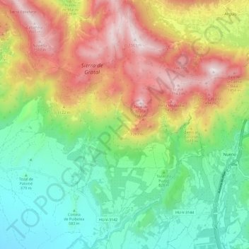
Name: Lierta topographic map, elevation, terrain.
Location: Lierta, La Sotonera, Hoya de Huesca, Huesca, Aragón, España (42.23411 -0.53452 42.31934 -0.44852)
Average elevation: 952 m
Minimum elevation: 533 m
Maximum elevation: 1,570 m
Thank you for supporting this site ❤️
Make a donation
Make a donation
Other topographic maps
Click on a map to view its topography, its elevation and its terrain.