
Bad Vöslau topographic map
Interactive map
Click on the map to display elevation.
About this map
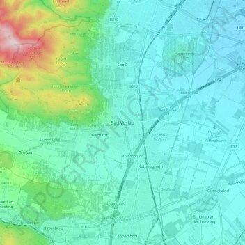
Name: Bad Vöslau topographic map, elevation, terrain.
Location: Bad Vöslau, Bezirk Baden, Niederösterreich, 2450, Österreich (47.92555 16.17481 48.00555 16.25481)
Average elevation: 299 m
Minimum elevation: 211 m
Maximum elevation: 699 m
Other topographic maps
Click on a map to view its topography, its elevation and its terrain.
Manhartsberg
Österreich > Niederösterreich > Gemeinde Bad Vöslau > Bad Vöslau
Manhartsberg, Bad Vöslau, Bezirk Baden, Niederösterreich, 2540, Österreich
Average elevation: 522 m