
Thank you for supporting this site ❤️
Make a donation
Make a donation
Hauenstein topographic map
Click on the map to display elevation.
Thank you for supporting this site ❤️
Make a donation
Make a donation
About this map
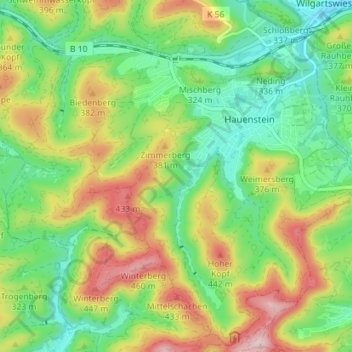
Name: Hauenstein topographic map, elevation, terrain.
Location: Hauenstein, Südwestpfalz, Rijnland-Palts, 76846, Duitsland (49.16248 7.80254 49.20697 7.87356)
Average elevation: 306 m
Minimum elevation: 208 m
Maximum elevation: 473 m
Thank you for supporting this site ❤️
Make a donation
Make a donation
Other topographic maps
Click on a map to view its topography, its elevation and its terrain.