
Make a donation
Hope Hull topographic map
Click on the map to display elevation.
Make a donation
About this map
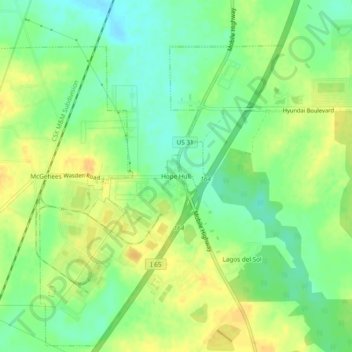
Name: Hope Hull topographic map, elevation, terrain.
Location: Hope Hull, Montgomery County, Alabama, United States (32.24986 -86.37719 32.28986 -86.33719)
Average elevation: 66 m
Minimum elevation: 51 m
Maximum elevation: 80 m
Make a donation
Other topographic maps
Click on a map to view its topography, its elevation and its terrain.
Montgomery
United States > Alabama > Montgomery County
Montgomery is located at 32°21′42″N 86°16′45″W / 32.36167°N 86.27917°W / 32.36167; -86.27917. According to the U.S. Census Bureau, the city has a total area of 156.2 square miles (405 km2), of which 155.4 square miles (402 km2) is land and 0.8 square miles (2.1 km2) (0.52%) is water. The…
Average elevation: 66 m
Woodmere Park
United States > Alabama > Montgomery County > Montgomery > Bellwood Plantation
Average elevation: 84 m
Montgomery
United States > Alabama > Montgomery County
According to the United States Census Bureau, the city has a total area of 162.27 square miles (420.3 km2), of which 159.86 square miles (414.0 km2) is land and 2.41 square miles (6.2 km2) (0.52%) is water. The city is built over rolling terrain at an elevation of about 220 feet (67 m) above sea level.
Average elevation: 66 m
Make a donation
Montgomery
United States > Alabama > Montgomery County
According to the United States Census Bureau, the city has a total area of 162.27 square miles (420.3 km2), of which 159.86 square miles (414.0 km2) is land and 2.41 square miles (6.2 km2) (0.52%) is water. The city is built over rolling terrain at an elevation of about 220 feet (67 m) above sea level.
Average elevation: 65 m