
Make a donation
Uxbridge topographic map
Click on the map to display elevation.
Make a donation
Uxbridge
The town is 30.4 square miles (79 km2), of which 0.8 square miles (2.1 km2), or 2.74%, is water. It is situated 39.77 miles (64.00 km) southwest of Boston, 16 miles (26 km) southeast of Worcester, and 20 miles (32 km) northwest of Providence. Elevations range from 200 feet (61 m) to 577 feet (176 m) above sea level. It borders Douglas, Mendon, Millville, Northbridge, and Sutton, Massachusetts, plus the Rhode Island towns of Burrillville and North Smithfield.
Make a donation
About this map
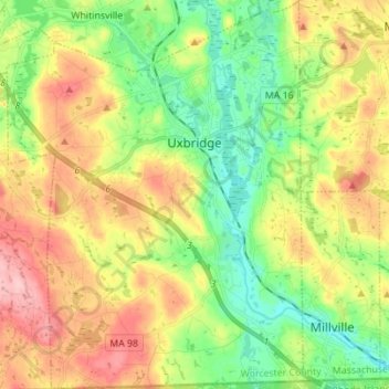
Name: Uxbridge topographic map, elevation, terrain.
Location: Uxbridge, Worcester County, Massachusetts, United States (42.01153 -71.69667 42.11428 -71.59110)
Average elevation: 115 m
Minimum elevation: 55 m
Maximum elevation: 195 m
Make a donation
Other topographic maps
Click on a map to view its topography, its elevation and its terrain.
Central (Stanley) Woolen Mill District Park
United States > Massachusetts > Worcester County > Uxbridge
Average elevation: 80 m
Make a donation
Wachusett Station
United States > Massachusetts > Worcester County > Fitchburg
Average elevation: 229 m
Make a donation
Crow Hill Ledges
United States > Massachusetts > Worcester County > Westminster
Average elevation: 293 m
Olde English Village
United States > Massachusetts > Worcester County > Gardner
Average elevation: 308 m
Make a donation
Vernon Hill
United States > Massachusetts > Worcester County > Worcester > Quinsigamond Village
Average elevation: 162 m
Make a donation
Tatnuck
United States > Massachusetts > Worcester County > Worcester > Tatnuck Square
Average elevation: 221 m
Make a donation
Institute Park
United States > Massachusetts > Worcester County > Worcester > Belmont Hill
Average elevation: 170 m
Make a donation
Hadwen Park
United States > Massachusetts > Worcester County > Worcester > Heard Street
Average elevation: 166 m
Make a donation
Thompsons Pond Dam
United States > Massachusetts > Worcester County > Spencer
Average elevation: 278 m
Make a donation
Make a donation
Northbridge Center
United States > Massachusetts > Worcester County > Northbridge
Average elevation: 124 m
Make a donation
Blackburn Village
United States > Massachusetts > Worcester County > Ashburnham
Average elevation: 326 m
Phillipston Four Corners
United States > Massachusetts > Worcester County > Phillipston
Average elevation: 335 m
Make a donation
Make a donation
Make a donation
Make a donation
South Charlton Reservoir
United States > Massachusetts > Worcester County > Charlton > South Charlton
Average elevation: 203 m
Make a donation
West Upton
United States > Massachusetts > Worcester County > Upton > West Upton
Average elevation: 111 m
Make a donation
Jefferson
United States > Massachusetts > Worcester County > Holden > Jefferson
Average elevation: 248 m
Hadwen Arboretum
United States > Massachusetts > Worcester County > Worcester > Main South
Average elevation: 165 m
Martha Templeton Rock
United States > Massachusetts > Worcester County > Southborough
Average elevation: 95 m
Make a donation
Make a donation
Turkey Hill Shores
United States > Massachusetts > Worcester County > Rutland
Average elevation: 312 m