
Make a donation
Milwaukee River Floodplain Forest State Natural Area topographic map
Click on the map to display elevation.
Make a donation
About this map
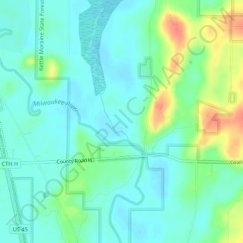
Name: Milwaukee River Floodplain Forest State Natural Area topographic map, elevation, terrain.
Average elevation: 291 m
Minimum elevation: 277 m
Maximum elevation: 326 m
Make a donation
Other topographic maps
Click on a map to view its topography, its elevation and its terrain.
Make a donation
West Bend
United States > Wisconsin > Washington County
West Bend is in the Kettle Moraine region, and its topography is varied. The glacial activity has formed many kettles and hills throughout the region.
Average elevation: 298 m
West Bend
United States > Wisconsin > Washington County
West Bend is in the Kettle Moraine region, and its topography is varied. The glacial activity has formed many kettles and hills throughout the region.
Average elevation: 298 m
Make a donation
West Bend
United States > Wisconsin > Washington County
West Bend is in the Kettle Moraine region, and its topography is varied. The glacial activity has formed many kettles and hills throughout the region.
Average elevation: 298 m
Village of Richfield
United States > Wisconsin > Washington County
According to the United States Census Bureau, the village has a total area of 36.46 square miles (94.43 km2), of which, 35.91 square miles (93.01 km2) of it is land and 0.55 square miles (1.42 km2) is water. The low point in the village lies in Section 1 at Little Cedar Creek with an elevation of 856 feet. The…
Average elevation: 296 m
Make a donation