
Make a donation
Black Jack Battlefield topographic map
Click on the map to display elevation.
Make a donation
About this map
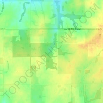
Name: Black Jack Battlefield topographic map, elevation, terrain.
Average elevation: 332 m
Minimum elevation: 315 m
Maximum elevation: 343 m
Make a donation
Other topographic maps
Click on a map to view its topography, its elevation and its terrain.
Lawrence
United States > Kansas > Douglas County
Lawrence is located at coordinates 38.9716689, -95.2352501 in the state of Kansas, approximately 25 miles (40 kilometers) east of Topeka, and 35 mi (56 km) west of Kansas City, Kansas. Though Lawrence has a designated elevation of 866 feet (264 m), the highest elevation is Mount Oread on the University of…
Average elevation: 265 m
Make a donation
Lawrence
United States > Kansas > Douglas County
Lawrence is located at coordinates 38.9716689, -95.2352501 in the state of Kansas, approximately 25 miles (40 kilometers) east of Topeka, and 35 mi (56 km) west of Kansas City, Kansas. Though Lawrence has a designated elevation of 866 feet (264 m), the highest elevation is Mount Oread on the University of…
Average elevation: 265 m
Make a donation
Lawrence
United States > Kansas > Douglas County
Lawrence is located approximately 25 miles (40 kilometers) east of Topeka, and 35 mi (56 km) west of Kansas City, Kansas. Though Lawrence has a designated elevation of 866 feet (264 m), the highest elevation is Mount Oread on the University of Kansas campus with an elevation of 1,020 feet (310 m).
Average elevation: 265 m
Lawrence
United States > Kansas > Douglas County
Lawrence is located approximately 25 miles (40 kilometers) east of Topeka, and 35 mi (56 km) west of Kansas City, Kansas. Though Lawrence has a designated elevation of 866 feet (264 m), the highest elevation is Mount Oread on the University of Kansas campus with an elevation of 1,020 feet (310 m).
Average elevation: 265 m