
Thank you for supporting this site ❤️
Make a donation
Make a donation
Naudin topographic map
Click on the map to display elevation.
Thank you for supporting this site ❤️
Make a donation
Make a donation
About this map
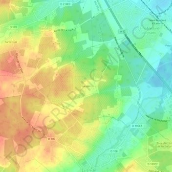
Name: Naudin topographic map, elevation, terrain.
Average elevation: 30 m
Minimum elevation: 4 m
Maximum elevation: 58 m
Thank you for supporting this site ❤️
Make a donation
Make a donation
Other topographic maps
Click on a map to view its topography, its elevation and its terrain.
Château d'Eyran
France > Nouvelle-Aquitaine > Gironde > Saint-Médard-d'Eyrans > Priou
Average elevation: 9 m