
Thank you for supporting this site ❤️
Make a donation
Make a donation
Casale Staffora topographic map
Click on the map to display elevation.
Thank you for supporting this site ❤️
Make a donation
Make a donation
About this map
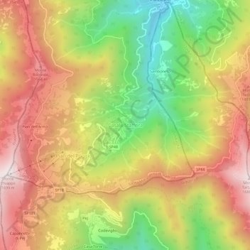
Name: Casale Staffora topographic map, elevation, terrain.
Average elevation: 1,265 m
Minimum elevation: 791 m
Maximum elevation: 1,689 m
Thank you for supporting this site ❤️
Make a donation
Make a donation
Other topographic maps
Click on a map to view its topography, its elevation and its terrain.
Pavia
From an elevation point of view, the city has various heights. The highest point is located in the area of the Visconti Castle, about 80 m (260 ft) above sea level, and then slowly declines. From an altitude of 80 m (260 ft), you pass to 77 m (253 ft) in about 500 m (550 yd; 1,600 ft). Downstream from Piazza…
Average elevation: 74 m
Thank you for supporting this site ❤️
Make a donation
Make a donation
Thank you for supporting this site ❤️
Make a donation
Make a donation
Thank you for supporting this site ❤️
Make a donation
Make a donation
Thank you for supporting this site ❤️
Make a donation
Make a donation