
Thank you for supporting this site ❤️
Make a donation
Make a donation
Bundibugyo topographic map
Click on the map to display elevation.
Thank you for supporting this site ❤️
Make a donation
Make a donation
Bundibugyo
The geographical coordinates of Bundibugyo town are:0°42'45.0"N 30°03'36.0"E (Latitude:0.712500; Longitude: 30.059999). Bundibugyo Town Council sits at an average elevation of 3,461 feet (1,055 m) above mean sea level, lying between 2,477 feet (755 m) and 7,733 feet (2,357 m) above sea level.
Thank you for supporting this site ❤️
Make a donation
Make a donation
About this map
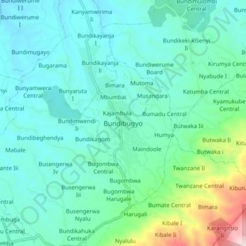
Name: Bundibugyo topographic map, elevation, terrain.
Average elevation: 994 m
Minimum elevation: 742 m
Maximum elevation: 2,122 m
Thank you for supporting this site ❤️
Make a donation
Make a donation