
Make a donation
Lyme topographic map
Click on the map to display elevation.
Make a donation
About this map
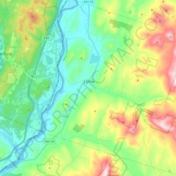
Name: Lyme topographic map, elevation, terrain.
Location: Lyme, Grafton County, New Hampshire, United States (43.73720 -72.20592 43.87270 -72.02690)
Average elevation: 299 m
Minimum elevation: 111 m
Maximum elevation: 711 m
Make a donation
Other topographic maps
Click on a map to view its topography, its elevation and its terrain.
Streeter Mountain
United States > New Hampshire > Grafton County > Dorchester
Average elevation: 449 m
Make a donation
Make a donation
Make a donation
Make a donation
Stinson Lake
United States > New Hampshire > Grafton County > Rumney > Stinson Lake
Average elevation: 460 m
Make a donation
Mount Kineo, East Peak
United States > New Hampshire > Grafton County > Ellsworth
Average elevation: 710 m
LeBruns Mobile Home Park
United States > New Hampshire > Grafton County > Lebanon > LeBruns Mobile Home Park
Average elevation: 326 m
Make a donation
West Lebanon
United States > New Hampshire > Grafton County > Lebanon > West Lebanon
Average elevation: 165 m
The Village of Loon Mountain
United States > New Hampshire > Grafton County > Lincoln
Average elevation: 532 m
Make a donation
North Littleton
United States > New Hampshire > Grafton County > Littleton > North Littleton
Average elevation: 333 m