
Make a donation
Bocas topographic map
Click on the map to display elevation.
Make a donation
About this map
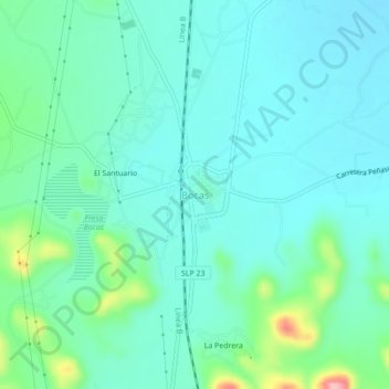
Name: Bocas topographic map, elevation, terrain.
Average elevation: 1,722 m
Minimum elevation: 1,691 m
Maximum elevation: 1,843 m
Make a donation
Other topographic maps
Click on a map to view its topography, its elevation and its terrain.
Fraccionamiento El Cortijo
México > San Luis Potosí > Municipio de San Luis Potosí > San Luis Potosí
Average elevation: 1,879 m
Industrial San Luis
México > San Luis Potosí > Municipio de San Luis Potosí > San Luis Potosí
Average elevation: 1,858 m
Colonia Lomas del Río
México > San Luis Potosí > Municipio de San Luis Potosí > San Luis Potosí
Average elevation: 1,885 m
Zona Industrial
México > San Luis Potosí > Municipio de San Luis Potosí > San Luis Potosí
Average elevation: 1,856 m
Make a donation
Parque Tangamanga
México > San Luis Potosí > Municipio de San Luis Potosí > San Luis Potosí
Average elevation: 1,919 m
Presa de San José
México > San Luis Potosí > Municipio de San Luis Potosí > San Luis Potosí
Average elevation: 1,981 m
Presa San José
México > San Luis Potosí > Municipio de San Luis Potosí > Escalerillas > Las Pilitas
Average elevation: 1,995 m
Centro Histórico
México > San Luis Potosí > Municipio de San Luis Potosí > San Luis Potosí
Average elevation: 1,869 m
Make a donation