
Make a donation
East Khasi Hills topographic map
Click on the map to display elevation.
Make a donation
About this map
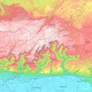
Name: East Khasi Hills topographic map, elevation, terrain.
Location: East Khasi Hills, Meghalaya, India (25.12272 91.35326 25.68253 92.15713)
Average elevation: 932 m
Minimum elevation: 4 m
Maximum elevation: 1,957 m
Make a donation
Other topographic maps
Click on a map to view its topography, its elevation and its terrain.
Shillong
HQ Eastern Air Command (HQ, EAC) was shifted to Shillong on 10 June 1963 from Kolkata and housed in the old buildings located at Nonglyer village at Upper Shillong, some 10 km (6.2 mi) from (Lower) Shillong, but at a greater altitude of around 1,800 metres (6,000 ft) AMSL. Initially a British military base, it…
Average elevation: 1,351 m
Make a donation
Shillong
HQ Eastern Air Command (HQ, EAC) was shifted to Shillong on 10 Jun 63 from Kolkata and housed in the old buildings located at Nonglyer village at Upper Shillong, some 10 km from (Lower) Shillong, but at a greater altitude of around 6,000 feet AMSL. Initially a British military base, it was taken over by No. 58…
Average elevation: 1,351 m
Make a donation
Make a donation
Lawkyntang (Sacred Grove)
India > Meghalaya > Khatarshnong Laitkroh > Mawphlang
Average elevation: 1,740 m
Make a donation
Shillong
HQ Eastern Air Command (HQ, EAC) was shifted to Shillong on 10 Jun 63 from Kolkata and housed in the old buildings located at Nonglyer village at Upper Shillong, some 10 km from (Lower) Shillong, but at a greater altitude of around 6,000 feet AMSL. Initially a British military base, it was taken over by No. 58…
Average elevation: 1,351 m
Make a donation
Shillong
HQ Eastern Air Command (HQ, EAC) was shifted to Shillong on 10 Jun 63 from Kolkata and housed in the old buildings located at Nonglyer village at Upper Shillong, some 10 km from (Lower) Shillong, but at a greater altitude of around 6,000 feet AMSL. Initially a British military base, it was taken over by No. 58…
Average elevation: 1,351 m
Jowai
India > Meghalaya > Thadlaskein
Jowai (IPA: ʤəʊˈwaɪ) is the headquarters of the West Jaintia Hills district of the state of Meghalaya, India, and is home to the Pnar, a sub-tribe of the Khasi people. It is located on a plateau surrounded on three sides by the Myntdu river bordering Bangladesh to the south (about 50 km from the…
Average elevation: 1,332 m
Make a donation
Make a donation
Make a donation
Sohra (Cherrapunji)
India > Meghalaya > Shella Bholaganj
It has an average elevation of 1,430 metres (4,690 ft) and sits on a plateau in the southern part of the Khasi Hills, facing the plains of Bangladesh. The plateau rises 660 meters above the surrounding valleys.
Average elevation: 1,169 m
Make a donation
Make a donation
Sohra (Cherrapunji)
India > Meghalaya > Shella Bholaganj
It has an average elevation of 1,430 metres (4,690 ft) and sits on a plateau in the southern part of the Khasi Hills, facing the plains of Bangladesh. The plateau rises 660 meters above the surrounding valleys.
Average elevation: 1,169 m
Make a donation
Nohsngithiang Falls (Seven Sisters)
India > Meghalaya > Shella Bholaganj > Nongthymmai
Average elevation: 1,043 m