
Gwaelod-y-garth topographic map
Interactive map
Click on the map to display elevation.
About this map
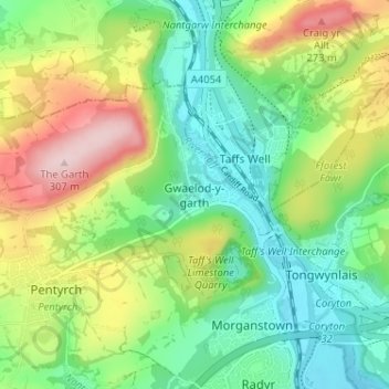
Name: Gwaelod-y-garth topographic map, elevation, terrain.
Average elevation: 124 m
Minimum elevation: 23 m
Maximum elevation: 303 m
Other topographic maps
Click on a map to view its topography, its elevation and its terrain.
Lisvane
Royaume-Uni > Pays de Galles > Cardiff
Lisvane, Cardiff, Pays de Galles, CF, Royaume-Uni
Average elevation: 114 m
River Taff
Royaume-Uni > Pays de Galles > Cardiff > Cardiff
River Taff, Cardiff, Pays de Galles, CF, Royaume-Uni
Average elevation: 196 m
Cardiff
Royaume-Uni > Pays de Galles > Cardiff
Cardiff, Pays de Galles, CF10 2AF, Royaume-Uni
Average elevation: 55 m