
Thank you for supporting this site ❤️
Make a donation
Make a donation
Allevard topographic map
Click on the map to display elevation.
Thank you for supporting this site ❤️
Make a donation
Make a donation
Allevard
The commune has a ski resort: the Collet d'Allevard which is located 10 km from the town (30 minutes drive). The altitude of the runs varies from 1,450m to 2,100m. The resort has 35 km of runs: 7 green, 6 blue, 5 red, and 3 black.
Thank you for supporting this site ❤️
Make a donation
Make a donation
About this map
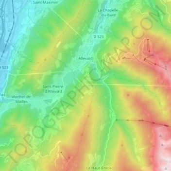
Name: Allevard topographic map, elevation, terrain.
Average elevation: 983 m
Minimum elevation: 238 m
Maximum elevation: 2,400 m
Thank you for supporting this site ❤️
Make a donation
Make a donation
Other topographic maps
Click on a map to view its topography, its elevation and its terrain.
La Bérarde
France > Auvergne-Rhône-Alpes > Isère > Saint-Christophe-en-Oisans
Average elevation: 2,307 m