
Make a donation
Farallon Island topographic map
Click on the map to display elevation.
Make a donation
About this map
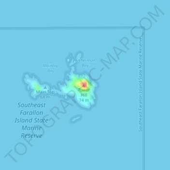
Name: Farallon Island topographic map, elevation, terrain.
Location: Farallon Island, San Francisco, California, United States (37.69913 -123.00176 37.69923 -123.00166)
Average elevation: 0 m
Minimum elevation: -2 m
Maximum elevation: 73 m
Make a donation
Other topographic maps
Click on a map to view its topography, its elevation and its terrain.
Golden Gate Park
United States > California > San Francisco
In the 1860s, San Franciscans began to feel the need for a spacious public park similar to Central Park, which was then taking shape in New York City. Golden Gate Park was carved out of unpromising sand and shore dunes that were known as the Outside Lands, in an unincorporated area west of San Francisco's…
Average elevation: 71 m
Make a donation
Make a donation
San Francisco Maritime National Historical Park
United States > California > San Francisco
Average elevation: 11 m
Make a donation
Make a donation
Golden Gate Park
United States > California > San Francisco
Conceived ostensibly for recreation, the underlying purpose of the park was housing development and the westward expansion of the city. Field engineer William Hammond Hall prepared a survey and topographic map of the park site in 1870 and became its commissioner in 1871. He was later named California's first…
Average elevation: 71 m
Make a donation
Make a donation