
Wüppingen topographic map
Interactive map
Click on the map to display elevation.
About this map
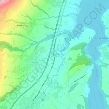
Name: Wüppingen topographic map, elevation, terrain.
Location: Wüppingen, Marsing, Greyerzbezirk, Freiburg, 1633, Schweiz (46.63868 7.05384 46.67868 7.09384)
Average elevation: 744 m
Minimum elevation: 663 m
Maximum elevation: 1,027 m
Other topographic maps
Click on a map to view its topography, its elevation and its terrain.
Botterens
Schweiz > Freiburg > Greyerzbezirk
Botterens, Greyerzbezirk, Freiburg, 1652, Schweiz
Average elevation: 832 m
Le Moléson
Schweiz > Freiburg > Greyerzbezirk > Gruyères
Le Moléson, Gruyères, Greyerzbezirk, Freiburg, 1663, Schweiz
Average elevation: 1,503 m
Jaun
Schweiz > Freiburg > Greyerzbezirk
Jaun, Greyerzbezirk, Freiburg, 1656, Schweiz
Average elevation: 1,487 m