
Thank you for supporting this site ❤️
Make a donation
Make a donation
Shirvan District topographic map
Click on the map to display elevation.
Thank you for supporting this site ❤️
Make a donation
Make a donation
Shirvan District
Throughout its history, Shirvan has suffered from floods because of its proximity to the river and the relatively low elevation of most of the town.
Thank you for supporting this site ❤️
Make a donation
Make a donation
About this map
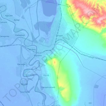
Name: Shirvan District topographic map, elevation, terrain.
Location: Shirvan District, Shirvan-Salyan, Azerbaijan (39.85551 48.87920 40.00430 48.98075)
Average elevation: 13 m
Minimum elevation: -26 m
Maximum elevation: 263 m
Thank you for supporting this site ❤️
Make a donation
Make a donation
Other topographic maps
Click on a map to view its topography, its elevation and its terrain.