
Mugono topographic map
Interactive map
Click on the map to display elevation.
About this map
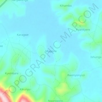
Name: Mugono topographic map, elevation, terrain.
Location: Mugono, Ntungamo, Western Region, Ouganda (-0.82202 30.28455 -0.78202 30.32455)
Average elevation: 1,497 m
Minimum elevation: 1,454 m
Maximum elevation: 1,760 m
Other topographic maps
Click on a map to view its topography, its elevation and its terrain.