
Thank you for supporting this site ❤️
Make a donation
Make a donation
Madenburg topographic map
Click on the map to display elevation.
Thank you for supporting this site ❤️
Make a donation
Make a donation
Madenburg
Die Madenburg wurde als Höhenburg am Ostrand des Pfälzerwalds auf einem in die Rheinebene vorspringenden Felsausläufer des 476,3 m hohen Rothenbergs erbaut. Die von Wald umgebene Ruine liegt etwa 250 m oberhalb von Eschbach auf einer Höhe von 458,5 m ü. NHN.
Thank you for supporting this site ❤️
Make a donation
Make a donation
About this map
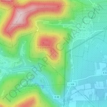
Name: Madenburg topographic map, elevation, terrain.
Average elevation: 290 m
Minimum elevation: 177 m
Maximum elevation: 519 m
Thank you for supporting this site ❤️
Make a donation
Make a donation