
Make a donation
Nayarit topographic map
Click on the map to display elevation.
Make a donation
Nayarit
Nayarit's natural vegetation varies with altitude; coastal lowlands and river valleys were, historically, covered with tropical dry forest, containing many native deciduous trees that lost their leaves during the dry seasons. The Sinaloan dry forests now cover the northern coastal lowlands, and extend up the valleys of the San Pedro Mezquital River and the Río Grande de Santiago and its tributaries. The Jalisco dry forests ecoregion covers coastal Nayarit south of San Blas and the Islas Marías.
Make a donation
About this map
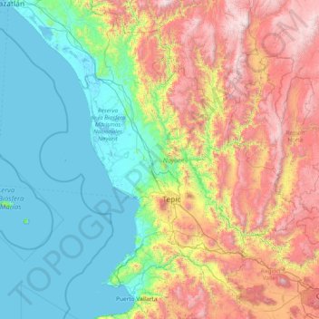
Name: Nayarit topographic map, elevation, terrain.
Location: Nayarit, Mexico (20.60322 -106.70322 23.08450 -103.72090)
Average elevation: 834 m
Minimum elevation: -2 m
Maximum elevation: 3,202 m
Make a donation
Other topographic maps
Click on a map to view its topography, its elevation and its terrain.
Puebla City
Mexico > Puebla > Municipio de Puebla
The Sierra del Tentzon and higher elevations of Malinche volcano still conserve the Trans-Mexican Volcanic Belt pine-oak forests ecoregion – with forests of pine, holm oak and other tree species. In the pine forests, Montezuma Pine (Pinus montezumae) is generally predominant, with Hartweg's Pine (Pinus…
Average elevation: 2,233 m
Culiacán
Culiacán is located in the central region of the State of Sinaloa, forming part of the Northwest of Mexico. The coordinates that correspond to it are 24 ° 48'15 "N (latitude) by 107 ° 25'52" W (West), with an altitude of 54 meters above sea level.
Average elevation: 85 m
San Luis Potosí City
Mexico > San Luis Potosi > Municipio de San Luis Potosí
San Luis Potosí, commonly referred to as San Luis, or by its initials SLP (Otomi: Nmiñ'u), is the capital and the most populous city of the Mexican state of San Luis Potosí. It is the municipal seat of the surrounding municipality of San Luis Potosí. The city lies at an elevation of 1,864 metres (6,115…
Average elevation: 2,004 m
Make a donation
Toluca
Mexico > State of Mexico > Toluca
Toluca is located at 2600 meters above sea level, being the highest capital city in Mexico and North America, which makes it temperate throughout the year with average temperatures ranging between 6 and 25 degrees Celsius during spring and summer, and from −5 to 20 degrees Celsius in winter. Its climate is…
Average elevation: 2,729 m
Saltillo
El Cerro del Pueblo (The Town Hill) and its 4-metre (13 ft) cross overlook the city. The city's elevation makes it colder and windier than the neighboring city of Monterrey. Saltillo lies in the Chihuahuan Desert near the city of Arteaga. The city is flanked by the Zapalinamé mountains, which are part of the…
Average elevation: 1,857 m
Make a donation
Puerto Vallarta
Mexico > Jalisco > Puerto Vallarta
In 1968, the Puerto Vallarta municipality was elevated to City status. The elevation in status reflected interest by Mexican federal and state governments in developing the Puerto Vallarta as an international resort destination. Puerto Vallarta has since also attracted a lively immigrant community from the…
Average elevation: 306 m