
Make a donation
Isfahan Province topographic map
Click on the map to display elevation.
Make a donation
Isfahan Province
With an elevation of 4,040 metres, the Shahankuh is the highest peak in Isfahan Province. This mountain is located about 20 kilometres southwest of the city of Fereydunshahr in the western part of Isfahan Province.
Make a donation
About this map
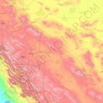
Name: Isfahan Province topographic map, elevation, terrain.
Location: Isfahan Province, Iran (30.70997 49.64063 34.51098 55.56122)
Average elevation: 1,535 m
Minimum elevation: 0 m
Maximum elevation: 4,267 m
Make a donation
Other topographic maps
Click on a map to view its topography, its elevation and its terrain.
Sarbisheh
Iran > South Khorasan Province > Sarbisheh County > دهستان مؤمن آباد
Average elevation: 1,860 m
Make a donation
Make a donation
شورستان
Iran > South Khorasan Province > Sarbisheh County > دهستان مؤمن آباد
Average elevation: 1,912 m
Baba Jan, East Azerbaijan
Iran > East Azerbaijan Province > Ahar County > دهستان قشلاق
Average elevation: 1,752 m
Make a donation
Pasak
Iran > Sistan and Baluchestan Province > Qasr-e-Ghand County > دهستان هیت > Pasak
Average elevation: 481 m