Geolocate

Spiti topographic map

Interactive map

Click on the map to display elevation.

About this map

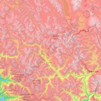
Name: Spiti topographic map, elevation, terrain.

Location: Spiti, Lahaul and Spiti District, Himachal Pradesh, India (31.75233 77.54923 32.98918 78.69266)

Average elevation: 4,906 m

Minimum elevation: 2,229 m

Maximum elevation: 6,741 m

Other topographic maps

Click on a map to view its topography, its elevation and its terrain.

Kullu

India > Himachal Pradesh > Kullu

Kullu, Himachal Pradesh, India

Average elevation: 3,631 m

Batal

India > Himachal Pradesh > Batal

Batal, Solan, Himachal Pradesh, 173208, India

Average elevation: 1,122 m

Lahul and Spiti

India > Himachal Pradesh

Lahul and Spiti, Himachal Pradesh, India

Average elevation: 4,276 m

Manali

India > Himachal Pradesh > Manali

Manali, Kullu, Himachal Pradesh, 175131, India

Average elevation: 2,606 m