
Make a donation
Batu topographic map
Click on the map to display elevation.
Make a donation
Batu
In the 19th century, the Dutch East Indies government developed Batu as a mountain resort. Villas and resort facilities were built in Batu during the period. Most of the topography of Batu City is dominated by highland and hilly terrain with valleys running down mountain slopes. In northern Batu, there is a dense forest, Raden Soerjo Forest Park, which is a protected forest area.
Make a donation
About this map
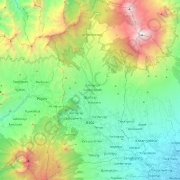
Name: Batu topographic map, elevation, terrain.
Location: Batu, Klojen, Java, Indonesia (-7.94107 112.47393 -7.72388 112.59499)
Average elevation: 1,365 m
Minimum elevation: 479 m
Maximum elevation: 3,308 m
Make a donation
Other topographic maps
Click on a map to view its topography, its elevation and its terrain.
Make a donation
Make a donation
Make a donation
Make a donation
Make a donation
Make a donation
Make a donation
Make a donation
Make a donation
Make a donation
Make a donation
Make a donation
Make a donation
Make a donation
Make a donation
Make a donation
Make a donation
Make a donation
RW 15 KEL. CIHANJUANG RAHAYU KEC. PAROMPONG KAB. BANDUNG BARAT
Indonesia > West Bandung > Cisarua > Villa Istana Bunga
Average elevation: 1,377 m
Make a donation
Make a donation
Make a donation
Make a donation
Make a donation
Make a donation
Make a donation