
Thank you for supporting this site ❤️
Make a donation
Make a donation
Hinterrhein topographic map
Click on the map to display elevation.
Thank you for supporting this site ❤️
Make a donation
Make a donation
About this map
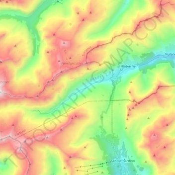
Name: Hinterrhein topographic map, elevation, terrain.
Location: Hinterrhein, Rheinwald, Viamala, Grisons, 7438, Suisse (46.47631 9.03896 46.55452 9.22202)
Average elevation: 2,334 m
Minimum elevation: 1,542 m
Maximum elevation: 3,321 m
Thank you for supporting this site ❤️
Make a donation
Make a donation
Other topographic maps
Click on a map to view its topography, its elevation and its terrain.