
Thank you for supporting this site ❤️
Make a donation
Make a donation
Tasiusaq topographic map
Click on the map to display elevation.
Thank you for supporting this site ❤️
Make a donation
Make a donation
About this map
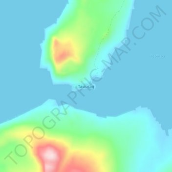
Name: Tasiusaq topographic map, elevation, terrain.
Location: Tasiusaq, Kujalleq, Greenland (60.17374 -44.83515 60.21374 -44.79515)
Average elevation: 49 m
Minimum elevation: -4 m
Maximum elevation: 323 m
Thank you for supporting this site ❤️
Make a donation
Make a donation
Other topographic maps
Click on a map to view its topography, its elevation and its terrain.