
Thank you for supporting this site ❤️
Make a donation
Make a donation
Saaremaa topographic map
Click on the map to display elevation.
Thank you for supporting this site ❤️
Make a donation
Make a donation
Saaremaa
More than 10,000 years ago the first parts of Saaremaa arose from the Baltic Ice Lake. The uplift of the Earth's crust is continuing even today at a rate of 2 mm (0.079 in) per year. The West Estonian islands are low-lying plains resting on limestone; their average elevation is roughly 15 meters (49 ft) above sea level. Limestone has become denuded in a great number of places, resulting in cliffs, limestone pits and quarries at Mustjala, Ninase, Pulli, Üügu and Kaugatuma.
Thank you for supporting this site ❤️
Make a donation
Make a donation
About this map
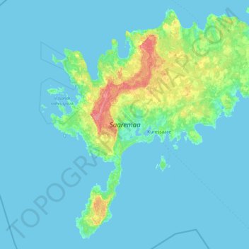
Name: Saaremaa topographic map, elevation, terrain.
Location: Saaremaa, Estonia (57.90539 21.82850 58.64229 23.32865)
Average elevation: 5 m
Minimum elevation: -1 m
Maximum elevation: 56 m
Thank you for supporting this site ❤️
Make a donation
Make a donation