
Badakhshan Province topographic map
Interactive map
Click on the map to display elevation.
About this map
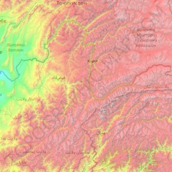
Name: Badakhshan Province topographic map, elevation, terrain.
Location: Badakhshan Province, Afghanistan (35.44337 69.98015 38.49107 74.88986)
Average elevation: 3,261 m
Minimum elevation: 338 m
Maximum elevation: 7,533 m
Other topographic maps
Click on a map to view its topography, its elevation and its terrain.
Kabul
Afghanistan > Kabul Province > Kabul District
Kabul, Kabul District, Kabul Province, 1001, Afghanistan
Average elevation: 1,945 m
Maymana
Afghanistan > Faryab Province > Maymana
Maymana, Faryab Province, Afghanistan
Average elevation: 989 m
Silsilah-ye Safēd Kōh
Silsilah-ye Safēd Kōh, Chishti Sharif, Herat, Afghanistan
Average elevation: 2,988 m
Hindu Kush
Hindu Kush, Wakhan, Badakhshan, Afghanistan
Average elevation: 5,164 m