
Amazonas topographic map
Interactive map
Click on the map to display elevation.
About this map
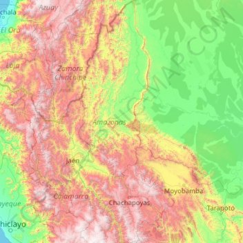
Name: Amazonas topographic map, elevation, terrain.
Location: Amazonas, Peru (-6.98676 -78.71218 -2.98607 -77.13230)
Average elevation: 1,119 m
Minimum elevation: -1 m
Maximum elevation: 4,213 m
Other topographic maps
Click on a map to view its topography, its elevation and its terrain.
San Cristóbal
Peru > Amazonas > San Cristóbal
San Cristóbal, Luya, Amazonas, Peru
Average elevation: 2,283 m
Pedro Ruiz Gallo
Pedro Ruiz Gallo, Jazán, Bongará, Amazonas, 01130, Peru
Average elevation: 1,598 m