
Thank you for supporting this site ❤️
Make a donation
Make a donation
Obernaundorf topographic map
Click on the map to display elevation.
Thank you for supporting this site ❤️
Make a donation
Make a donation
Obernaundorf
Nahe dem Freigut entspringt der Vorholzbach sowie in der Geßliche das gleichnamige Bächlein. Im Nordosten erhebt sich der Wachtelberg (369,3 m über Meereshöhe), im Nordwesten der Kahler-Berg (335,2 m über Meereshöhe).
Thank you for supporting this site ❤️
Make a donation
Make a donation
About this map
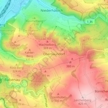
Name: Obernaundorf topographic map, elevation, terrain.
Average elevation: 310 m
Minimum elevation: 175 m
Maximum elevation: 425 m
Thank you for supporting this site ❤️
Make a donation
Make a donation