
Feldhausen topographic map
Interactive map
Click on the map to display elevation.
About this map
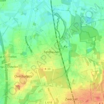
Name: Feldhausen topographic map, elevation, terrain.
Average elevation: 55 m
Minimum elevation: 36 m
Maximum elevation: 82 m
Other topographic maps
Click on a map to view its topography, its elevation and its terrain.
Eigen
Allemagne > Rhénanie-du-Nord-Westphalie > Bottrop
Eigen, Bottrop, Regierungsbezirk Münster, Rhénanie-du-Nord-Westphalie, 46240, Allemagne
Average elevation: 50 m
Bottrop
Allemagne > Rhénanie-du-Nord-Westphalie > Bottrop
Bottrop, Regierungsbezirk Münster, Rhénanie-du-Nord-Westphalie, 46236, Allemagne
Average elevation: 57 m