
Klebas topographic map
Interactive map
Click on the map to display elevation.
About this map
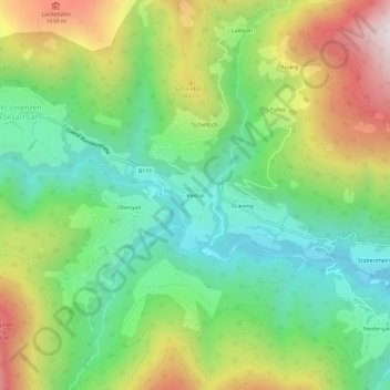
Name: Klebas topographic map, elevation, terrain.
Average elevation: 1,261 m
Minimum elevation: 911 m
Maximum elevation: 1,842 m
Other topographic maps
Click on a map to view its topography, its elevation and its terrain.
Birnbaum
Oostenrijk > Karinthië > Bezirk Hermagor > Lesachtal > Nostra
Birnbaum, Nostra, Lesachtal, Bezirk Hermagor, Karinthië, 9652, Oostenrijk
Average elevation: 1,153 m
Maria Luggau
Oostenrijk > Karinthië > Bezirk Hermagor > Lesachtal > Maria Luggau
Maria Luggau, Lesachtal, Bezirk Hermagor, Karinthië, 9655, Oostenrijk
Average elevation: 1,449 m