
Thank you for supporting this site ❤️
Make a donation
Make a donation
Battagram topographic map
Click on the map to display elevation.
Thank you for supporting this site ❤️
Make a donation
Make a donation
Battagram
Battagram (Urdu: بٹگرام, Pashto: بټګرام) is a city and Union Council of Battagram District in Khyber Pakhtunkhwa Province of Pakistan. It is located at 34°41'N 73°1'E and has an altitude of 1038 metres (3408 feet).
Thank you for supporting this site ❤️
Make a donation
Make a donation
About this map
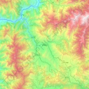
Name: Battagram topographic map, elevation, terrain.
Average elevation: 1,778 m
Minimum elevation: 497 m
Maximum elevation: 3,784 m
Thank you for supporting this site ❤️
Make a donation
Make a donation
Other topographic maps
Click on a map to view its topography, its elevation and its terrain.