
Thank you for supporting this site ❤️
Make a donation
Make a donation
Carrara topographic map
Click on the map to display elevation.
Thank you for supporting this site ❤️
Make a donation
Make a donation
About this map
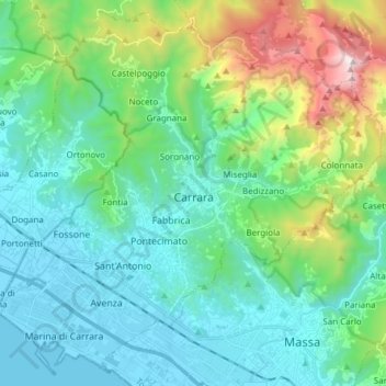
Name: Carrara topographic map, elevation, terrain.
Location: Carrara, Massa-Carrara, Tuscany, 54033, Italy (44.02666 10.01876 44.12975 10.17111)
Average elevation: 377 m
Minimum elevation: -1 m
Maximum elevation: 1,715 m
Thank you for supporting this site ❤️
Make a donation
Make a donation
Other topographic maps
Click on a map to view its topography, its elevation and its terrain.
Thank you for supporting this site ❤️
Make a donation
Make a donation
Monte Citerna
Italy > Tuscany > Metropolitan City of Florence > Barberino di Mugello
Average elevation: 733 m