
Thank you for supporting this site ❤️
Make a donation
Make a donation
Selce topographic map
Click on the map to display elevation.
Thank you for supporting this site ❤️
Make a donation
Make a donation
About this map
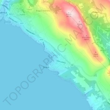
Name: Selce topographic map, elevation, terrain.
Average elevation: 84 m
Minimum elevation: -1 m
Maximum elevation: 378 m
Thank you for supporting this site ❤️
Make a donation
Make a donation
Other topographic maps
Click on a map to view its topography, its elevation and its terrain.
Vrbovsko
Croatie > Comitat de Primorje-Gorski Kotar
Au nord, la rivière Kupa sépare Vrbovsko de la Slovénie voisine. La limite orientale de la municipalité passe par les villages de Zdihovo, Liplje et Bosiljevo ; elle traverse la vallée de la Dobra près de Ljubošina. La limite occidentale part des gorges de la Kupa à Radočaj, contourne Razdrto et…
Average elevation: 519 m
Mjesni odbor Belveder
Croatie > Comitat de Primorje-Gorski Kotar > Grad Rijeka
Average elevation: 79 m
Thank you for supporting this site ❤️
Make a donation
Make a donation
Thank you for supporting this site ❤️
Make a donation
Make a donation
Thank you for supporting this site ❤️
Make a donation
Make a donation