
Thank you for supporting this site ❤️
Make a donation
Make a donation
Province of Abancay topographic map
Click on the map to display elevation.
Thank you for supporting this site ❤️
Make a donation
Make a donation
About this map
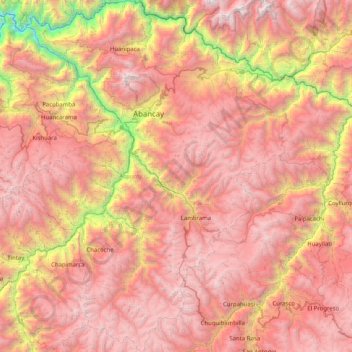
Name: Province of Abancay topographic map, elevation, terrain.
Location: Province of Abancay, Apurímac, 03041, Peru (-14.17039 -73.17190 -13.38303 -72.39879)
Average elevation: 3,563 m
Minimum elevation: 1,027 m
Maximum elevation: 5,379 m
Thank you for supporting this site ❤️
Make a donation
Make a donation
Other topographic maps
Click on a map to view its topography, its elevation and its terrain.