
Thank you for supporting this site ❤️
Make a donation
Make a donation
Reifferscheid topographic map
Click on the map to display elevation.
Thank you for supporting this site ❤️
Make a donation
Make a donation
About this map
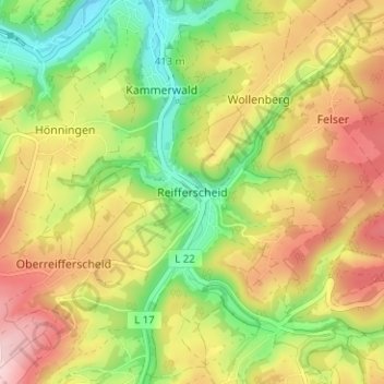
Name: Reifferscheid topographic map, elevation, terrain.
Average elevation: 499 m
Minimum elevation: 389 m
Maximum elevation: 616 m
Thank you for supporting this site ❤️
Make a donation
Make a donation
Other topographic maps
Click on a map to view its topography, its elevation and its terrain.
Urftsee
Duitsland > Noordrijn-Westfalen > Kreis Euskirchen > Schleiden > Vogelsang Internationaler Platz (IP)
Average elevation: 397 m