
Thank you for supporting this site ❤️
Make a donation
Make a donation
Sutton topographic map
Click on the map to display elevation.
Thank you for supporting this site ❤️
Make a donation
Make a donation
About this map
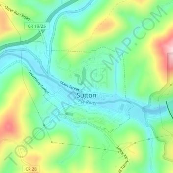
Name: Sutton topographic map, elevation, terrain.
Location: Sutton, Braxton County, West Virginia, United States (38.65838 -80.72897 38.67255 -80.69984)
Average elevation: 320 m
Minimum elevation: 243 m
Maximum elevation: 479 m
Thank you for supporting this site ❤️
Make a donation
Make a donation
Other topographic maps
Click on a map to view its topography, its elevation and its terrain.