
Puck topographic map
Interactive map
Click on the map to display elevation.
About this map
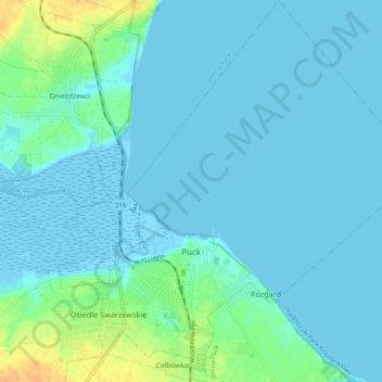
Name: Puck topographic map, elevation, terrain.
Location: Puck, Puck County, Pomeranian Voivodeship, Poland (54.70069 18.37660 54.75834 18.47161)
Average elevation: 5 m
Minimum elevation: -6 m
Maximum elevation: 30 m
Other topographic maps
Click on a map to view its topography, its elevation and its terrain.
Władysławowo
Poland > Pomeranian Voivodeship > Puck County
Władysławowo, Puck County, Pomeranian Voivodeship, Poland
Average elevation: 11 m
Dębki
Poland > Pomeranian Voivodeship > Puck County
Dębki, gmina Krokowa, Puck County, Pomeranian Voivodeship, 84-110, Poland
Average elevation: 0 m
Hel
Poland > Pomeranian Voivodeship > Puck County
Hel, Puck County, Pomeranian Voivodeship, 84-150, Poland
Average elevation: 0 m
Puck
Poland > Pomeranian Voivodeship > Puck County > Puck
Puck, Puck County, Pomeranian Voivodeship, 84-100, Poland
Average elevation: 9 m
Zele
Poland > Pomeranian Voivodeship > Puck County > Łebcz
Zele, Łebcz, gmina Puck, Puck County, Pomeranian Voivodeship, 84-103, Poland
Average elevation: 17 m