
Thank you for supporting this site ❤️
Make a donation
Make a donation
Galdames topographic map
Click on the map to display elevation.
Thank you for supporting this site ❤️
Make a donation
Make a donation
About this map
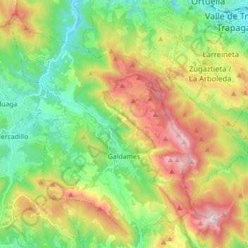
Name: Galdames topographic map, elevation, terrain.
Location: Galdames, Biscaye, Pays basque autonome, 48191, Espagne (43.22593 -3.15583 43.30547 -3.03215)
Average elevation: 334 m
Minimum elevation: 6 m
Maximum elevation: 866 m
Thank you for supporting this site ❤️
Make a donation
Make a donation
Other topographic maps
Click on a map to view its topography, its elevation and its terrain.
Sojoguti/Soxoguti
Espagne > Pays basque autonome > Aiarako koadrilla/Cuadrilla de Ayala > Artziniega
Average elevation: 338 m