
Thank you for supporting this site ❤️
Make a donation
Make a donation
Eggjarklettur topographic map
Click on the map to display elevation.
Thank you for supporting this site ❤️
Make a donation
Make a donation
About this map
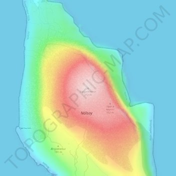
Name: Eggjarklettur topographic map, elevation, terrain.
Location: Eggjarklettur, Nólsoy, Streymoyar sýsla, 270, Færøerne (61.98919 -6.65272 61.98929 -6.65262)
Average elevation: 98 m
Minimum elevation: -24 m
Maximum elevation: 362 m
Thank you for supporting this site ❤️
Make a donation
Make a donation