Geolocate

霞山区 (Xiashan) topographic map

Interactive map

Click on the map to display elevation.

About this map

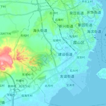
Name: 霞山区 (Xiashan) topographic map, elevation, terrain.

Location: 霞山区 (Xiashan), Fort-Bayard, Guangdong, RPC (21.12049 110.31531 21.24295 110.44235)

Average elevation: 22 m

Minimum elevation: -4 m

Maximum elevation: 157 m

Other topographic maps

Click on a map to view its topography, its elevation and its terrain.

Yingde

RPC > Guangdong > Yingde

Yingde, 英德市 (Yingde), 清远市 (Qingyuan), Guangdong, 513000, RPC

Average elevation: 167 m

Péninsule de Leizhou

RPC > Guangdong > 东坡南村

Péninsule de Leizhou, 207国道, 东坡南村, 雷州市 (Leizhou), Fort-Bayard, Guangdong, RPC

Average elevation: 29 m

Meizhou

RPC > Guangdong > Meizhou

Meizhou, 梅江区 (Meijiang), 梅州市 / Meizhou, Guangdong, 514000, RPC

Average elevation: 232 m

Lechang

RPC > Guangdong > Lechang

Lechang, 乐昌市 (Lechang), 韶关市 (Shaoguan), Guangdong, RPC

Average elevation: 447 m

Jiangmen

RPC > Guangdong > Jiangmen

Jiangmen, 蓬江区 (Pengjiang), 江门市 / Jiangmen, Guangdong, 529000, RPC

Average elevation: 18 m