
Cerro del León topographic map
Interactive map
Click on the map to display elevation.
About this map
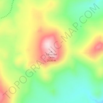
Name: Cerro del León topographic map, elevation, terrain.
Location: Cerro del León, Departamento Picunches, NQN, Argentine (-38.79457 -70.56738 -38.79447 -70.56728)
Average elevation: 1,834 m
Minimum elevation: 1,682 m
Maximum elevation: 2,022 m
Other topographic maps
Click on a map to view its topography, its elevation and its terrain.
Cerro La Campana
Cerro La Campana, Departamento Catán Lil, NQN, Argentine
Average elevation: 1,453 m
Cerro Centinela
Cerro Centinela, Comisión de Fomento de Manzano Amargo, Departamento Minas, NQN, Argentine
Average elevation: 1,939 m