
Isenthal topographic map
Interactive map
Click on the map to display elevation.
About this map
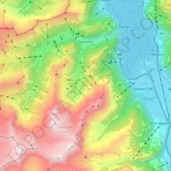
Name: Isenthal topographic map, elevation, terrain.
Location: Isenthal, Uri, 6461, Schweiz (46.84025 8.45830 46.92797 8.60784)
Average elevation: 1,395 m
Minimum elevation: 424 m
Maximum elevation: 2,925 m
Other topographic maps
Click on a map to view its topography, its elevation and its terrain.
Andermatt
Schweiz > Uri > Korporation Ursern
Andermatt, Korporation Ursern, Uri, 6490, Schweiz
Average elevation: 2,127 m
Klausenpass
Klausenpass, Klausenstrasse, Spiringen, Uri, Schweiz
Average elevation: 2,103 m
Oberalppass
Schweiz > Uri > Korporation Ursern > Andermatt
Oberalppass, Andermatt, Korporation Ursern, Uri, 6490, Schweiz
Average elevation: 2,219 m