
Thank you for supporting this site ❤️
Make a donation
Make a donation
Sungai Buloh topographic map
Click on the map to display elevation.
Thank you for supporting this site ❤️
Make a donation
Make a donation
About this map
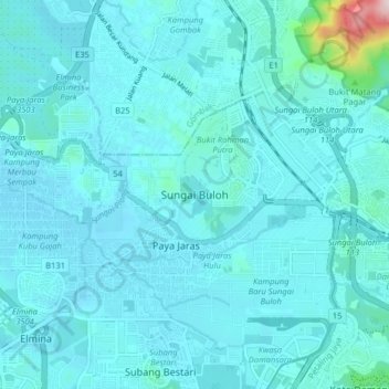
Name: Sungai Buloh topographic map, elevation, terrain.
Location: Sungai Buloh, Shah Alam, Petaling, Selangor, 40160, Malaysia (3.17000 101.51000 3.25000 101.59000)
Average elevation: 51 m
Minimum elevation: 14 m
Maximum elevation: 475 m
Thank you for supporting this site ❤️
Make a donation
Make a donation
Other topographic maps
Click on a map to view its topography, its elevation and its terrain.