
Thank you for supporting this site ❤️
Make a donation
Make a donation
Ampsen topographic map
Click on the map to display elevation.
Thank you for supporting this site ❤️
Make a donation
Make a donation
About this map
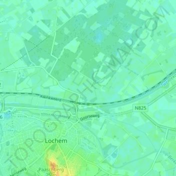
Name: Ampsen topographic map, elevation, terrain.
Location: Ampsen, Lochem, Gelderland, Nederland, 7241 NG, Nederland (52.15042 6.40642 52.19042 6.44642)
Average elevation: 14 m
Minimum elevation: 8 m
Maximum elevation: 32 m
Thank you for supporting this site ❤️
Make a donation
Make a donation
Other topographic maps
Click on a map to view its topography, its elevation and its terrain.