
Thank you for supporting this site ❤️
Make a donation
Make a donation
Orrs Mill topographic map
Click on the map to display elevation.
Thank you for supporting this site ❤️
Make a donation
Make a donation
About this map
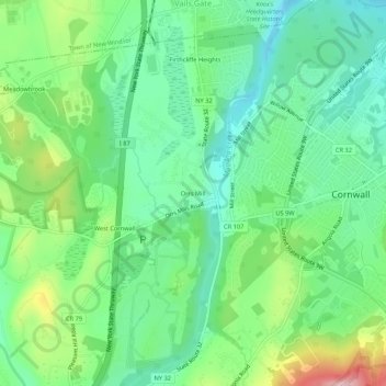
Name: Orrs Mill topographic map, elevation, terrain.
Average elevation: 94 m
Minimum elevation: 29 m
Maximum elevation: 237 m
Thank you for supporting this site ❤️
Make a donation
Make a donation
Other topographic maps
Click on a map to view its topography, its elevation and its terrain.
Salisbury Mills
United States > New York > Orange County > Town of Cornwall > Salisbury Mills
Average elevation: 118 m
Village of Cornwall-on-Hudson
United States > New York > Orange County > Town of Cornwall
Average elevation: 124 m