
Thank you for supporting this site ❤️
Make a donation
Make a donation
Ngamprah topographic map
Click on the map to display elevation.
Thank you for supporting this site ❤️
Make a donation
Make a donation
Ngamprah
Ngamprah has an elevation moderated tropical rainforest climate (Af) with moderate rainfall from June to September and heavy rainfall from October to May.
Thank you for supporting this site ❤️
Make a donation
Make a donation
About this map
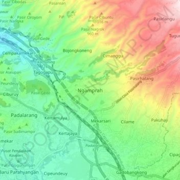
Name: Ngamprah topographic map, elevation, terrain.
Location: Ngamprah, West Bandung, West Java, Java, 40552, Indonesia (-6.87076 107.46247 -6.79076 107.54247)
Average elevation: 803 m
Minimum elevation: 565 m
Maximum elevation: 1,238 m
Thank you for supporting this site ❤️
Make a donation
Make a donation
Other topographic maps
Click on a map to view its topography, its elevation and its terrain.
DUSUN IV DESA MUKAPAYUNG KEC. CILILIN KAB. BANDUNG BARAT
Indonesia > West Java > West Bandung
Average elevation: 918 m
Thank you for supporting this site ❤️
Make a donation
Make a donation