
Thank you for supporting this site ❤️
Make a donation
Make a donation
Dairy Flat topographic map
Click on the map to display elevation.
Thank you for supporting this site ❤️
Make a donation
Make a donation
About this map
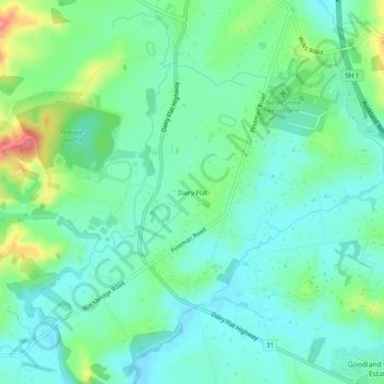
Name: Dairy Flat topographic map, elevation, terrain.
Location: Dairy Flat, Rodney, Auckland, 0794, New Zealand (-36.68656 174.62365 -36.64656 174.66365)
Average elevation: 59 m
Minimum elevation: 32 m
Maximum elevation: 135 m
Thank you for supporting this site ❤️
Make a donation
Make a donation
Other topographic maps
Click on a map to view its topography, its elevation and its terrain.